Tag Archives: historical

Rescuing Black History in the Fillmore

San Franciscans of Japanese descent during forced evacuation of the city in 1942. Photo by the Department of the Interior, War Relocation Authority.

African Americans have been a part of San Francisco since before the Gold Rush. The city’s Black population saw its greatest increase, however, during World War II. Hailing primarily from Louisiana and Texas, the newcomers  had been recruited to work in Bay Area shipyards.  Many settled into homes in the Western Addition recently vacated by San Franciscans of Japanese descent who had been forced, under President Franklin D. Roosevelt’s Executive Order 9066, to relocate to internment camps.

Over the following two decades, a visible African American presence established itself in the Western Addition neighborhood around Fillmore Street. This included a vibrant jazz and rhythm-and-blues nightclub scene that featured such artists such as Duke Ellington, Louis Armstrong, Billie Holiday, Count Bassie, Thelonious Monk, and Ella Fitzgerald. When Justin Herman took control of the San Francisco Redevelopment Agency in 1959, however, he oversaw the razing of much of the Fillmore and the forcible removal of Black residents from the neighborhood, bringing an end to the Fillmore jazz era. James Baldwin’s 1963 documentary, “Take This Hammer,” addresses the fallout; it can be seen online for free.

Ella Fitzgerald and Fillmore celebrants in the 1950s. Courtesy the Red Powell/Reggie Pettus Collection.

Elizabeth Pepin and Lewis Watts have been working for many years to rescue the neighborhood’s Black music history – including Pepin’s work as associate producer on the 1999 KQED documentary, The Fillmore. In 2006, they published Harlem of the West: The San Francisco Fillmore Jazz Era. The book was released with a companion website and an exhibit that traveled to venues including the Museum of Performance and Design in San Francisco and the California African American Museum in Los Angeles.

Featured on the cover of the 2006 edition were, l-r: John Handy, Pony Poindexter, John Coltrane, Frank Fisher at Jimbo’s Bop City in the 1950s. Photo by Steven Jackson Jr.

Performing at the Herbst Theater in conjunction with the 2006 publication of Harlem of the West were John Handy (2nd from left) and Frank Fisher (3rd from left) who had appeared on the book’s cover. Photo courtesy Lewis Watts.

Currently, Pepin and Watts are preparing a revised edition of the book. It will feature a new design and Introduction, as well as additional material based on the oral histories they have recorded and photographs they have collected since the book was first published.

In part, it was photographs that first prompted the creation of the book – specifically, pictures that hung on the walls of Red’s Shine Parlor, a shoeshine business on Fillmore Street. Following owner Red Powell’s untimely death, his photographs were rescued by Reggie Pettus, owner of the New Chicago Barbershop across Fillmore street from Red’s Shine Parlor. Pettus, in turn, made them available to Lewis Watts.
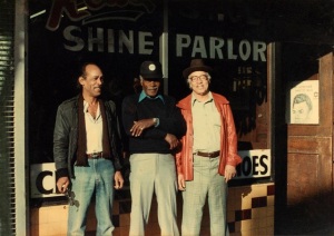
Red Powell (far right) in front of his shoeshine parlor in the 1960s. Courtesy the Red Powell/Reggie Pettus Collection.

Many of the photos lacked information about the photographers and the people and places they portrayed. Elizabeth Pepin collaborated with Watts, who teaches photography at UC Santa Cruz, to identify the photographs. Pepin pursued her research at a time when little scholarship had done about African American history in San Francisco aside from a handful of works such as Douglas Henry Daniels’ Pioneer Urbanites and Albert Broussard’s Black San Francisco. Also at that time, Bay Area archival repositories such as the California Historical Society, the Bancroft Library, and the San Francisco History Center had little material about the city’s Black history.

Elizabeth Pepin and Lewis Watts. Photo courtesy Lewis Watts.

Since the initial publication of the book, Pepin and Watts have discussed their work with a wide range of audiences. In response, they have received ongoing offers of additional photographs and oral history recording sessions. It was this new content that prompted their decision to release an expanded version of their book – as well as audio files of some of those oral histories in future iterations of their website. As Pepin explained to me,

 The Fillmore was pretty much gone by the time I entered the world. I didn’t feel I had the right to put my voice into that. Obviously, I’m choosing out of all the interviews.  But really the book is written by the people who lived the history. I feel very strongly that this stuff needs to be available to the public. I think that there are many, many more stories to be told in the Fillmore. It’s important that this material be made available so that other people can put it toward their own projects.

Pepin and Watts’s work is especially pertinent in light of the failure of other attempts to capture and communicate the Fillmore’s African American past.  In 1995, the San Francisco Redevelopment Agency, which had previously decimated the Fillmore neighborhood, launched the mismanaged Fillmore Jazz Preservation District project. The mandate had been to commission permanent interpretive art installations, offer financial support for Black businesses, and establish jazz venues such as Yoshi’s as well as the Jazz Heritage Center (where material from Pepin and Watts’s work has been exhibited), but the results have been mixed. The neighborhood further suffered when a Community Benefit District, which was established in 2006 to promote Fillmore heritage and businesses, was shuttered in 2012 following infighting among the area’s businesses owners and residents.

malcolm x

As part of the Fillmore Jazz Preservation District project, this sidewalk marker outside the Fillmore Auditorium originally read, “Malcolm X Spoke At The Fillmore Auditorium, 1962.” The brick  that featured the name “Malcolm X” has been replaced, but his name has not. 2012 photo by Drew Bourn.

Such disappointments make Pepin and Watts’s efforts to document and share the Black history of the Fillmore all the more vital.  If you have photographs or can help identify persons and places in Pepin and Watts’s existing photograph collections, or if you might be willing to share your recollections of the period, please contact Pepin and Watts. Such contributions are welcome as they prepare their new and expanded edition of Harlem of the West.

3 Comments

Filed under Bancroft Library, California Historical Society, San Francisco History Center

“Bitter Melon” – Reinterpreting the Dewey Monument in Union Square

Robert Aitken’s 1903 sculpture atop the Dewey Monument. Alma de Bretteville was the model. The trident represents Admiral George Dewey’s naval victory. The wreath honors the memory of U.S. President William McKinley, who was assassinated in 1901 by Leon Czolgosz. 2008 photo by Carnaval.com Studios.

Although the U.S. declared victory in the Spanish-American War, Filipino insurgents continued to fight for their independence – this time, against the United States. That conflict – the Philippine-American War – began in 1899 and lasted until the U.S. military quelled the rebellion in 1902. Again, U.S. troops were deployed through the Presidio in San Francisco. Thus, in both the Spanish-American War and the Philippine-American War, military personnel were sent through one former Spanish colony (San Francisco) to fight military personnel  in another former Spanish colony (the Philippines).

In the year following the conclusion of the Philippine-American War, the Dewey Monument, a collaboration of sculptor Robert Aitken and architect Newton Tharp, was dedicated in San Francisco’s Union Square. The monument commemorates Admiral George Dewey’s defeat of the Spanish in Manilla Bay in the Philippines, and celebrates the American victory in the Spanish-American War.

The Dewey Monument in Union Square. 2006 photo by Robert Cutts.

Now, over a century later, the Dewey Monument is the subject of a new collaborative work by local artists. On May 25-28, 2012 at 8:00 p.m., “Bitter Melon” will be performed in Union Square as part of the annual Union Square Live program. Ben Wood and his technologist, David Mark, will do large-scale 3D video projections on the Dewey Monument, while choreographer Raissa Simpson and her Push Dance Company will use dance and movement. Their project reinterprets the significance of the Dewey Monument by drawing attention to the costs of war and by considering the ways that war can set human migrations in motion – including the resettlement of Filipinos in the San Francisco Bay Area.

Wood and Simpson, the lead artists, are approaching their interpretations of the Dewey Monument in slightly different ways. Wood is focusing primarily on the Philippine-American War and subsequent attempts by the United States to extend its military influence in the Pacific Rim. He is combining previously-existing film and video content with original material. For the images that he will project onto the Dewey Monument, Wood’s sources include a personal Philippines travelogue film, “Message to Magellan,” as well as his own photographs of cannons in San Francisco’s Presidio that date from the days when California was under Spanish control. Using the soundtrack of the Phoenix Learning Group’s 1974 documentary “The Lure of Empire: America Debates Imperialism,” Wood has selected actors’ spoken recreations of the testimony of Emilio Aguinaldo, Mark Twain, and other participants and contemporary commentators on the Philippine-American War.  Wood will combine these sound recordings with original music composed by José Gimena and performed on traditional Filipino instruments.

A sample of the images that will be projected in 3D on the Dewey Monument by Ben Wood and David Mark.

Regarding public monuments, Wood commented to me,

We often ignore them. There’s a thousand people walking around Union Square not paying attention to the Dewey Monument. How can we bring this story to life? What would happen if we looked at the monument as having been complicit in the notion of war as glorious? What if we looked at it as a living thing that’s been a witness to the horrors and tragedies of war?

Whereas Wood will be depicting specific persons and events, Simpson is taking a different approach. She has drawn on stories from her own Filipino and African American heritage to inspire the Push Dance Company’s performance in “Bitter Melon.” In particular, she has turned to the her family’s experience of the Great Mississippi Flood of 1927, which she speculates may have galvanized the migration of African Americans from the South to other parts of the United States in a way that foreshadowed the later migration of African Americans from the South to San Francisco during World War II. Simpson has also drawn upon her family’s experience during the Philippine-American War. During that conflict, American military personnel subjected Filipino prisoners to a form of torture called the “water cure.” Simpson was struck by the way in which water – something necessary for human life – had galvanized her family to migrate in order to escape flood and torture. The conflicting meanings of water are highlighted in the performance’s title. Bitter melon is a watery vegetable that figured prominently in the Filipino foods that Simpson ate as a youth. Her family had left the Philippines – and the devastating ways water was used there – yet brought the practices of making and sharing watery, life-giving food with them.

Push Dance Company in rehearsals for “Bitter Melon”

As Simpson observed,

This is a piece about what happens to people when they are subjected to violence, tragedy, forced labor, natural disaster. What does that do to people? I told my dancers they’re not necessarily portraying anyone in historical times. I don’t rely on the dancers to tell the story. I’m dealing with the emotionality. I asked my dancers – what was the first time that you had to leave home, the first time you migrated? How did you end up in San Francisco? What compelled you to stay? It’s important to realize that people back then came to San Francisco for some of the same reasons that you and I did.

“Bitter Melon” will be performed May 25-28, 2012 at 8:00 p.m. in Union Square. The event is free and open to the public. For more information, please visit the Push Dance Company website.

3 Comments

Filed under Uncategorized

Sharing Leather History Through a Board Game

Soldiers shipping out of Fort Mason. 1945 photo by PARC, Golden Gate National Recreation Area.

During World War II, an unprecedented number of military personnel were deployed through San Francisco to fight Japan in the Pacific Theater. It was also during World War II that a new military policy was implemented for the first time: the discharging of any personnel who were gay. Sent back to San Francisco, many of those who had been discharged chose to stay in the city rather than return to their hometowns after having been “outed.” Some historians, including Allan Bérubé, John D’Emilio, Nan Alamilla Boyd, and Susan Stryker and Jim Van Buskirk, have suggested this marked a new beginning for San Francisco as a site of gay organizing and activism.

Some of the gay men who settled in San Francisco were drawn to the outlaw image of bikers in popular media, including Marlon Brando’s 1953 film, The Wild One. They founded motorcycle groups such as the Warlocks, the California Motor Club, and the Barbary Coasters. It was partly out of these motorcycle groups that a new breed of urban gay man emerged: the “leatherman.” Many of these men wore black leather gear and denim, regardless of whether or not they rode a motorcycle. In contrast to the theatrical styles of femininity used by drag queens, leathermen developed and eroticized a distinctively masculine appearance and deportment. They sought each other out for heightened sexual experiences that included bondage, role-playing, and fetishes. Having been isolated, stigmatized and criminalized for their sexual desires, they upheld community-building and the pursuit of pleasure as the organizing principles of their lives.

By the 1960s, San Francisco leathermen had begun to create an elaborate all-male social world that came to include hundreds of bars, bathhouses, motorcycle runs, fraternal organizations, and other venues and events. Many of these institutions were centered around Folsom Street in the South of Market. In addition to providing places to build community and to meet potential sexual partners, the bars and bathouses were often the only venues where leathermen could showcase their photography, murals, and other art that portrayed their lives and experiences. This milieu thrived until the 1980s and 1990s when the combined impact of AIDS and neighborhood redevelopment ended Folsom Street’s days as the “Valley of the Kings.”

José Guevara behind the bar at the Powerhouse. 2012 photo by Drew Bourn.

José Guevara tends bar at the Powerhouse, one of the few remaining leather bars on Folsom Street. In 2008, he began to draft an historical map of the neighborhood that he kept at the bar. During his shifts, he solicited patrons’ recollections of the venues and events that had been in the area.

Paul Johnson of Off Ramp Leathers and artist Mike Caffee have been among the many friends and bar patrons who have generously shared their memories and memorabilia with Guevara. He has also conducted research in the archives of the GLBT Historical Society and reviewed the scholarly work on his topic – including the late Eric Rofes’ historical tours of the South of Market, and Gayle Rubin’s publications, such as Sites, Settlements, and Urban Sex: Archaeology and the Study of Gay Leathermen in San Francisco, 1955-1995.

José’s game includes a board, cards, dice and playing pieces such as a replica of a  leather motorcyle cap. 2012 photo by Drew Bourn.

Guevara soon realized that the material he was amassing could more easily be accommodated in the format of a game than a map. With friends’ assistance, he transformed the map into a 16″x 52″ board game with dice, playing pieces, and a stack of trivia cards. The board is lamenated and fits easily on the bar. The outside edge of the board portrays current businesses in the South of Market, along with a timeline and an epigraph from South of the Slot,  Jack London’s 1909 short story about the neighborhood. The center of the board represents leathermen’s venues and events that existed in the South of Market from 1962 until 1984. The project is a work-in-progress, and Guevara continues to develop the game as his research proceeds.

While he is considering other formats – including a publication, an online version, and an app for mobile phones – Guevara has been especially gratified that the game is played in the bar. As he commented to me,

I’m hoping that it’s something that brings them to the bar during my shift. The patrons are engaging each other, and I’m engaging them. You’re getting people to talk about their lives without having to say, “the party is over.” Sometimes people get lost in that. This is a chance to acknowledge them and the time that people spent in creating their community. It’s a chance to ask, “How did this community form? Where is it now? Where is it going?”

The gameboard. ©2009 José Guevara, Michael Moreno and Arturo Cortes.

You can join the game and reminisce at the Powerhouse, 1347 Folsom Street, when José Guevara starts his shift on Tuesdays, Wednesdays and Saturdays at 4:00 p.m. You can also review the recent proposal by the Western SoMa Citizens Planning Task Force to the San Francisco Planning Department to recognize and promote the neighborhood’s leather history.

Leave a comment

Filed under GLBT Historical Society

“The Maltese Falcon” – Copies Without an Original

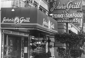
The Maltese Falcon statue that had been displayed at John's Grill. It was stolen in 2007 and remains missing. 2006 photo by Eddie Codel.

In Dashiell Hammett’s 1930 noir thriller  The Maltese Falcon, private detective Sam Spade encounters an international gang of thieves who have come to San Francisco on the trail of a stolen statue – “a glorious golden falcon encrusted from head to foot with the finest jewels… painted or enameled over to look like nothing more than a fairly interesting black statuette.” Hammett describes the disguised treasure as a “foot-high figure of a bird, black as coal and shiny where its polish was not dulled by wood-dust and fragments of excelsior.” The plot also involves a fake of the disguised statue – a black enameled copy made to resemble the original.

Since its initial publication, the novel has been adapted for both stage and screen. Perhaps the most famous adaptation has been John Huston’s 1941 film starring Humphrey Bogart as Sam Spade.

John's Grill, at 63 Ellis Street. 2006 photo by Mark Coggins.

According to Steve Rubenstein and John Koopman of the San Francisco Chronicle,  John Konstin, the owner of John’s Grill, sought to purchase one of the statue props from the 1941 film for display in his restaurant. Konstin’s restaurant is mentioned in The Maltese Falcon, and he has used that connection to promote his business. Although he was unable to acquire the movie prop, he did receive a plaster copy that Warner Bros. had created for publicity purposes. The plaster cast came to Konstin from Elisha Cook, Jr. – a San Francisco actor who played gunsel Wilmer Cook in the film. This statue was a copy (the plaster cast) of a copy (the prop from the film) of a copy (the fake statue). Konstin prominently displayed the statue in his restaurant until 2007, when – like the statue in the novel and film – it was stolen. To replace it, Konstin commissioned Academy of Art professor Peter Schiffrin to create a new bronze version of the statue – a copy of a copy of a copy of a copy.

The replacement falcon, created by Schiffrin and his students and now on display at John's Grill. 2011 photo by Eddie Codel.

That statue at John’s Grill is not the only Maltese falcon to be found in San Francisco. In fact, there are multiple statues. Whereas a group of crows is a called a “murder,” and a group of larks is an “exaltation,” a group of falcons is a “cast.” The term is particularly apt when describing the falcon statues in San Francisco insofar as the term reminds one of a cast of a statue, which serves as a copy; or a cast of actors, whose job it is to impersonate.

In addition to the statue at John’s Grill, another statue has been in Dashiell Hammett’s former apartment at 891 Post Street #401. Hammett lived there while writing The Maltese Falcon in the 1920s,  and some literary critics also identify it as Sam Spade’s apartment in the novel. Former occupant Bill Arney, who is affiliated with the Film Noir Foundationredesigned the apartment as an homage to Hammett – including a statue of the falcon. Writer Robert Mailer Anderson has since taken over the apartment and taken additional steps to restore it to the way it appeared when Hammett lived there. The apartment’s interior is now featured on the poster for this year’s Noir City film festival.

891 Post Street. Apartment #401 is on the top floor, on the corner at the intersection. 2012 photo by Drew Bourn.

Another of the statues is on display in the lobby of the Flood Building at 870 Market Street. Hammett had worked in that building as a private detective for the Pinkerton Detective Agency. Another statue is displayed behind the bar at the Tosca Café in North Beach. Owner Jeanette Etheridge has recounted that she discovered the statue at the bar when she bought it decades ago, and that its origins are a mystery. Another statue is located in the Dashiell Hammett Suite at the Hotel Union Square. Yet another Maltese falcon appears in the artwork above the consession area at the Metreon movie theater. Don Herron, who has been leading a Dashiell Hammett walking tour since 1977, has shared with me his understanding that a Maltese falcon statue once stood in what is now the Nordstrom department store at 895 Market Street, the former site of Samuels Jewelers where Hammett had once worked; and that he has seen statues of the Maltese Falcon displayed in the offices of local detective agencies.

Above the concession stand at the Metreon movie theater. 2011 photo by Drew Bourn.

I’ve created a Google Map to indicate the location of these Maltese falcon statues. If you are aware of additional statues, please feel free to let me know – I’d be glad to include them on the map. If you decide to go hunting for the statues, it might interest you that Market Street Railway Museum has described the 1920s public transportation that the characters from The Maltese Falcon would have used to move among some of these locations.

The fact that there are now so many Maltese falcon statues located throughout San Francisco is interesting for at least two reasons. First, it is ironic insofar as the plot of Hammett’s novel  revolved around the difficulty that the characters encountered in trying to locate the statue – a difficulty that was compounded by the existence of a copy. Secondly, the existence of so many statues recalls the work of Jewish German philosopher Walter Benjamin. In his 1936 essay, The Work of Art in the Age of Mechanical Reproduction, Benjamin contrasts photography and film with other forms of art. Whereas painting or drawing involves creating an original from which copies can be made, film and photography have no originals. Each print that is struck from a negative is identical to every other print; each is a copy, but no “original” positive print of the film or photograph exists. For movies like John Huston’s “The Maltese Falcon,” endless new prints can be struck from the film negative, but there is no “original” film positive in the same way that there can be an original painting. Similarly, the reproductions of the Maltese falcon statue can be seen as copies for which there is no original. Hammett’s 1930 novel is a work of fiction – it does not recount a real episode of San Francisco history, and there was never an actual Maltese falcon statue. Yet despite the absence of any original statue, copies nevertheless proliferate in San Francisco today just as multiple prints of Huston’s film exist.

For those who are interested in further background on the statue, two publications may be of interest: Don Herron’s Dashiell Hammett Tour Guidebook and Richard Layman’s Discovering the Maltese Falcon and Sam Spade.

For film enthusiasts, the Tenth Annual Noir City film festival will be featuring a special Dashiell Hammett program on Sunday, January 29 at the Castro Theatre. The screenings will include both Roy Del Ruth’s 1931 version of “The Maltese Falcon,” as well as John Huston’s 1941 version.

2 Comments

Filed under Uncategorized

Changing Place Names to Change Historical Memory

Oakland-based graphic designer Kenji Liu has recently embarked on a project that puts him in a long line of artists and polititians who have changed place names in San Francisco. His Decolonized Area Rapid Transit (DART) map is based on the official San Francisco Bay Area Rapid Transit (BART) station map. Liu has substituted the names of counties, bridges, transit stations and natural features that appear on the BART map with the names of local Native people and progressive political activists. In doing so, Liu has provided a vivid demonstration of the potential for using place names to invoke or erase local history. That same potential has also been revealed in battles over re-naming that have occurred repeatedly in San Francisco.

In the Great Earthquake and Fire of 1906, thousands of San Franciscans lost their homes and began a process of re-settling the city in new patterns of density and demographics. Three years after the disaster, a commission of the Board of Supervisors convened to address those population shifts by updating the names of the city’s streets and reducing the confusion of new place names. Many of the changes – such as eliminating the multiple use of the same name for different streets – provoked little or no controversy. However, upon proposing renaming streets of the Richmond and Sunset districts with names drawn from California’s Spanish past, some residents of those neighborhoods protested vociferiously. They denounced the prospect of becoming San Francisco’s “Spanish Town” so soon after the U.S. victory in the Spanish-American war. While some concessions to residents were made by the Board of Supervisors, the use of Spanish names (such as Anza, Balboa, Cabrillo, Arguello, and Ortega) was nevertheless implemented for many of the streets.

Editorial, San Francisco Call, November 24, 1909, page 6.

Other street name changes have been less ambitious than those carried out by the 1909 commission. In 1988, Beat poet Lawrence Ferlinghetti successfully petitioned the San Francisco Board of Supervisors to change the names of twelve streets to commemorate local writers and artists. The new names included Jack Kerouac Alley, Isadora Duncan Alley, Dashiell Hammett Street, and Via Bufano.

Nick Jaina band performing in Jack Kerouac Alley. 2008 photo by Chantel Williams.

While Ferlinghetti’s changes highlighted the city’s artistic past, other San Francisco streets have been re-named to highlight the city’s political past. The Board of Supervisors voted in 1985 to change the name of Brenham Place, on the west side of Portsmouth Square in San Francisco Chinatown, to Walter U. Lum Place, in recognition of the Chinese American journalist, educator and civil rights activist. Another civil rights activist was acknowledged when the block of Polk Street in front of City Hall was renamed Dr. Carlton B. Goodlett Place in 1999 in honor the local African American publisher and physician. Similar changes have met with resistance, however.  When the Board of Supervisors changed the name of Army Street to César Chávez Street in 1995, some white residents of the street organized a citywide ballot proposition to reverse the change. Their efforts were defeated, and the street continues to be named after the famed Mexican American labor organizer.

Intersection of César Chávez Street and Mission Street. 2008 photo by Freya Gefn.

In addition to streets, the names of neighborhoods have also been the subject of proposed changes. In some cases, the proposals are perhaps only partly serious. JohnnyO, writer of the local blog Burrito Justice, has proposed the name La Lengua (Spanish for “the Tongue”) for a portion of the Mission District. In part, his writing about La Lengua helps to highlight the work of the San Francisco Association of Realtors to continually change neighborhood names in the hopes of increasing sales. Reverend Malcolm Byrd of the First A.M.E. Zion Church has addressed this issue in more earnest terms when he has decried realtors’ naming a portion of the Western Addition neighborhood “NOPA,” or “North of the Panhandle,” in an effort to erase the area’s African American history and population and make potential home sales more appealing to white buyers.

The animal rights organization People for the Ethical Treatment of Animals (P.E.T.A.) also proposed a change of name of a San Francisco neighborhood when it lobbied Mayor Ed Lee in 2011 to change “The Tenderloin” to “The Tempeh District.” P.E.T.A. argued that the current name “echoes the violence and cruelty of the meat industry” and was inappropriate in a city with “some of the best vegan cuisine in the world.” The proposal met with some incredulity and was not pursued by either Mayor Lee or Supervisor Jane Kim, whose district includes the Tenderloin. As historian Peter Field notes on his walking tour, the name “Tenderloin” emerged in the nineteenth century out of the neighborhood’s role as a vice district. To change the name to “Tempeh” would risk losing a marker of that history.

Whether proposed name changes have been intended as official city policy (such as the work of the 1909 commission), or conspicuously unofficial (such as Kenji Liu’s DART map), or somewhere in between (such as the work of the San Francisco Association of Realtors), each example highlights the ways in which place names can function to highlight or obscure the site-specific history of San Francisco.

9 Comments

Filed under Uncategorized

Geotagging: Using Maps to Organize Historic Images

Map of San Francisco Chinatown, ca. 1901. Bancroft Library, G4364.S5:2C45 1901.C4.

Map of San Francisco Chinatown, ca. 1901. Bancroft Library, University of California, Berkeley. G4364.S5:2C45 1901.C4.

In recent years, a handful of projects have used online map programs such as Google Maps to provide access to historic images of San Francisco. These programs allow website creators or users to “geotag” digital versions of historic images – in other words, to situate the digital images on an online map. Some of these projects are examples of Web 2.0, meaning that users are able to make contributions by uploading images of their own, or add tags or comments to others’ photos. By considering some of these projects together, it is possible to compare their features. I’ll discuss five projects here, and then raise three issues related to this kind of work.

One project is HistoGrafica. Users can upload images, as well as a free-text description of the image and its source. Users can also contribute to others’ photos by rating the image, adding it to a list of their favorites, recommending it to other users, or suggesting that the location assigned to the image may be incorrect. Images can be searched by location on the map or keywords that search the images’ descriptions, and search results can be limited to a range of years.

Another project is Sepia Town, by Jon Protas, Eric Warren and Eric Lehnartz. Like Histographica, users can upload photos, provide a free-text description, indicate the image’s location, and identify its source. Images can be searched by a location keyword, geographic coordinates, or using the map, but keyword searches do not search the descriptions of the images. Also, the search results cannot be limited by a range of years. Sepia Town does, however, offer a split-screen “Then and Now” feature allowing the user to see an historic photo on the left and a contemporary Google Street View image of the same location on the right. Of course, users can make mistakes in identifying the location of the images they’ve uploaded. Because the site doesn’t offer the option to tag or comment on others’ photos, users would have to contact the website owners to suggest that any mistakes had been made.

WhatWasThere is similar to Sepia Town in that users can search for images only by using the map or inputing keywords related to locations, and search results cannot be limited by a range of years. Whereas Sepia Town uses a split screen presentation to view both an historic image and a current shot of the same location on Google Street View, WhatWasThere allows users to superimpose the historic image directly over a shot from Google Street View and to adjust the historic image’s opacity using a slider bar. As with Sepia Town, in cases where an incorrect location is assigned to an image, there is not a means for other users to tag or comment on the image in order to suggest changes.

Sometimes a map-based set of San Francisco historic images is presented in a Web 1.0 format, instead of a Web 2.0 format. This means that only the creators of the site can make changes or new contributions to it. One example is Dan Vanderkam and Raven Keller‘s project, Old SF. Vanderkam and Keller have used images and their descriptions exclusively from one source – the San Francisco History Center‘s online collection of historic photographs. Users can search for images on the map and can limit the search results by a range of years. The Web 1.0 format means that if users have an interest in making their own contributions (such as providing additional images, or offering further information about images), they would contact the site creators rather than directly making the contributions on the site itself.  A Web 1.0 format is easier to design than a Web 2.0 site, and it allows creators to have creative control over the site and its contents.

Vanderkam and Keller have done a tremendous amount of work in identifying the locations of images approximately 13,000 images from the collections of the San Francisco History Center. Building on that work, the San Francisco History Center has plans to further develop its own contributions to another Web 2.0 map project, Historypin. Historypin is perhaps the most ambitious of the current Web 2.0 mapping projects.  In addition to features seen in the other projects discussed above, it also provides further options for user contributions – including upload of video and audio content.

A few issues arise with the emergence of map-based collections of historic images. One issue derives from the very fact that there is more than one project: researchers have to keep track of multiple sites in order to search for images they need. A similar challenge had been faced by researchers searching for digital versions of rare books, which archives had previously uploaded to a bewildering variety of locations. These locations included their own websites as well as third-party hosts such as Google Books, the Hathi Trust, and the Internet Archive. Recently, archives have been increasingly collaborating to aggregate their content into consolidated sites (such as the Medical Heritage Library project) both to reduce duplication of effort as well as to improve ease of research.

A second issue is copyright violations. Although the copyright of some historical images has expired, many site designers and contributors remain confused or uninformed about copyright law. Resources are available to clarify the copyright status of various works – one example is the excellent Copyright Chart by Peter Hirtle of Cornell University. Nevertheless, site users’ compliance with copyright law continues to be a challenge.

Finally, there are risks associated with the content of user contributions. Site creators cannot easily control or monitor contributions, and those contributions can include everything from innaccuate information (such as incorrectly identifying the locations of images on a map) to libelous statements or other inappropriate content. This year, the OCLC Social Metadata Working Group is publishing a report for archives, libraries and museums to address the challenges associated with hosting user-generated content on their websites. The first of the three parts of the report is already available for free online.

The projects considered here represent an ongoing attempt to improve access to historical images by making them available online, and by using crowdsourcing to geographically locate and describe those images. For more information about the projects, and to see how they continue to develop in both their features and content, please visit their websites:  HistoGrafica, Sepia Town, WhatWasThereOld SF, and Historypin.

2 Comments

Filed under Bancroft Library, San Francisco History Center

Reenacting the Civil War at Fort Point

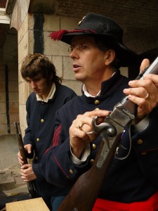
Civil War Reenactors at Fort Point. 2009 photo by Penny Meyer.

On August 13, 2011 from 10:00 a.m. to 5:00 p.m., Civil War Living History Day will take place at Fort Point in San Francisco’s Presidio, in the Golden Gate National Recreation Area.

San Francisco supported the Union during the American Civil War in the form of volunteer military recruits and the provision of many millions of dollars in gold. In turn, the city was impacted by measures to protect San Francisco Bay from possible Confederate or foreign aggression – including the installation of new batteries on Fort Point, Alcatraz, and Angel Island.

Following the Union victory and possibly as early as the 1890s panoramic exhibitions of the American Civil War were staged in San Francisco.  “Living history” reenactments – in which performers portray historical persons for audiences outside of traditional theatrical settings – have provided further opportunities to interpret the Civil War-era San Francisco. While living history programs can be found in many other parts of California (for example,  Cultural Heritage Day at Fort Ross, Living History and Pioneer Demonstration Days at Sutter’s Fort, Living History Day at the Petaluma Adobe State Historic Park, and the Old Sacramento Living History Program), Civil War reenactment at the Fort Point is one of the few living history programs in San Francisco.

The National Civil War Association first organized Civil War reenactments at Fort Point in the 1980s in cooperation with the National Park Service.  The program was discontinued in the 1990s, but was revived around 1998 by Mike Musante of the 20th Maine Volunteer Infantry, Company G, a unit of the American Civil War Association. Musante originally created the event as the occasion for the 20th Maine’s annual meeting and elections. Since then, Musante and a team of associates have worked with the Park Rangers of the Golden Gate National Recreation Area to stage Civil War reenactments at Fort Point every January and most Augusts.

Civil War Reenactor at Fort Point. 2009 photo by Penny Meyer.

Reenactors at the Fort Point events are all volunteers, and they are drawn from a variety of organizations, including the American Civil War Association, National Civil War Association, California Historical Artillery Society, Reenactors of the American Civil War, and Sons of Union Veterans of the Civil War. They perform infantry and artillery drills and demonstrate a range of activities from soldiers’ and civilians’ everyday lives – including sewing, quilting, doing laundry, dancing, using telegraph equipment, and medical and surgical procedures. Fife and drum music is performed by the California Consolidated Drum Band, and additional period music is provided by the Fort Point Garrison Brass Band. As Musante explained to me,

“The primary purpose of the event is to provide an educational experience to the visiting public.  We hope to give them an idea of what life was like at the Fort during the period, and some other general military impressions from the Civil War, particularly focusing on life in the Union Army… As a secondary objective we use this as an opportunity to practice our drill in between regular weekend events… and train new recruits.”

Civil War Reenactors at Fort Point. 2010 photo by Craig Glassner.

Organizers of the event emphasize what they regard as appropriate attire for reenactors, instructing them not to wear “blue jeans or sunglasses” or “non- period jewelry and wristwatches.” This speaks to a distinction made by some living history performers among so-called “farbs” (those who allow for anachronisms in their costuming), “mainstream” performers (who strive for authenticity in outward appearance and stay in character in front of audiences) and “progressives” (who seek authenticity in their costuming beyond outward appearance and who stay in character throughout the duration of an event). National Park Service regulations prohibit reenactors from staying in character when interacting with members of the public, but otherwise Musante characterized most of the reenactors at Fort Point as mainstream, along with “a good handful that are progressive.” Because the costs associated with appropriate costuming might otherwise be prohibitive for potential new recruits, items of military and civilian clothing are available on loan.

For an example of a unit of the American Civil War Association that will be participating in Civil War Living History Day on August 13, see the website of the 69th New York Volunteer Infantry, Company B. For additional information about the event, see the event webpage on the site of the 20th Maine Volunteer Infantry, Company G.

2 Comments

Filed under National Park Service

Chinese/LGBT: Comparing Two Local History Institutions

The Chinese Historical Society of America (CHSA) and the Gay, Lesbian, Bisexual, Transgender Historical Society (GLBT Historical Society) portray the lives and histories of two overlapping San Francisco communities. The two institutions share a number of interesting similarities.

Chinese Historical Society of America. 2004 photo by Smart Destinations.

The CHSA was founded in 1963. Architect Philip Choy curated exhibits as the CHSA grew and migrated from one Chinatown location to another, including Jack Kerouak Alley, Commercial Street, Broadway, and (since 2001) the current location at 965 Clay Street. The present site has over 10,400 square feet of exhibit and public programming space. It features Chinese in America: Toward a More Perfect Union in the main gallery as well as smaller rotating exhibits.

Gay, Lesbian, Bisexual, Transgender History Museum. 2011 photo by Daniel Nicoletta.

The GLBT Historical Society was founded in 1985 and changed locations more than once before establishing its current site at 657 Mission Street in 2003. The Mission Street site featured both archival collections for researchers as well as exhibits until 2010, when the GLBT Historical Society tested a temporary exhibition at the corner of 18th and Castro: Passionate Struggle: Dynamics of San Francisco’s GLBT History. Encouraged by the positive response, the GLBT Historical Society formally opened a more permanent GLBT History Museum at 4127 – 18th Street in 2011. The museum has approximately 1,600 square feet of exhibit and public programming space. This includes Our Vast Queer Past in the main gallery and space for smaller rotating exhibits. The Mission Street site continues to operate as an archives for researchers.

Both institutions began partly as a kind of archival rescue mission in response to dramatic transitions taking place in their respective communities. During the 1960s, many California Chinatowns were disappearing as residents moved out or passed away. The CHSA chartered bus trips to vanishing Chinatowns in Weaverville, San Luis Obispo, Hooverville, and elsewhere, gathering donations in the form of documents and artifacts ranging from boats to baskets to business signs. One donation included an entire temple altar from Napa. During the 1980s, the AIDS epidemic ravaged San Francisco’s gay male population. Thousands of local men died estranged from their families and without heirs, and the possessions that documented their lives risked being lost.  The GLBT Historical Society was founded in part to salvage those materials.

The relationship between each institution and academia has been complex. Both institutions’ founders and supporters have included pioneers who established some of the earliest academic programs and scholarship about their respective communities. CHSA board members Him Mark Lai and Philip Choy were not academically trained as historians, but they developed the first Chinese American history courses at San Francisco State University and University of California, Berkeley. Early GLBT Historical Society supporters Alan Berube and Eric Garber were also not academically-trained historians, but their scholarship was instrumental in establishing a place for lesbian, gay, bisexual and transgender history in academia. Today, both institutions continue to be supported both by independent scholars (such as Charlie Chin at the CHSA and Gerard Koskovich at the GLBT Historical Society) as well as academics who work within the now-established fields of Asian American Studies and Gay and Lesbian Studies. At various times each institution has partnered with other organizations for the purpose of managing selected collections. Whereas the CHSA has sought this support from within academia (working with the Ethnic Studies Library at the University of California, Berkeley), the GLBT Historical Society looked outside academia by partnering with the Hormel Center at the San Francisco Public Library. At one point in its history, the CHSA was affiliated with the Asian American Studies Department at San Francisco State University. Presently, however, neither institution is formally affiliated with a university. This has sometimes presented challenges. For example, the CHSA’s annual publication, History and Perspectives, is not a peer-reviewed academic journal along the lines of Johns Hopkins University’s Journal of Asian American Studies. Consequently, it can be more difficult for the editors to solicit contributions from academics.

Chinese American lesbian artist Lenore Chinn has contributed to the programming of both institutions. Photo by Erik Butler.

The significance of each institution’s location (CHSA in Chinatown, GLBT History Museum in the Castro) is worth considering. Prior to 1965, San Francisco Chinatown residents were predominantly Cantonese-speaking immigrants from the Pearl River Delta and their descendants. The Immigration and Nationality Act of 1965 had a major impact on the demographics of San Francisco Chinatown, bringing in both Chinese professionals and refugees from many other parts of Asia.  CHSA exhibits and programs have focused primarily on the history of the Pearl River Delta immigrants and their descendants, but the newer residents of Chinatown don’t always identify with that history. The Castro location has helped to make the GLBT History Museum a destination for tourists from around the world. At the same time, however, Castro residents have been grappling with the question of what it might mean that the neighborhood may be becoming less predominantly gay.

Finally, it is worth noting the role that both institutions have played in fostering activism. The CHSA’s traveling exhibit about the Chinese Exclusion Act, Remembering 1882, has prompted Chinese American activists in Washington, D.C. to advocate for an apology from Congress regarding the 1882 federal law. The public programming at the GLBT History Museum has provided a unique venue in the Castro to address issues such as housing rights, healthcare, aging, and labor organizing. Projects such as these at both institutions are in keeping with the fact that the very practice of documenting and interpreting Chinese American and GLBT history is itself an inherently political act.

For more information about each institution, visit the websites of the Chinese Historical Society of America and the Gay, Lesbian, Bisexual, Transgender Historical Society.

Leave a comment

Filed under Chinese Historical Society of America, GLBT Historical Society

“Ten Years” Tour: Using New Technology for History

Chris Carlsson installing a "Ten Years" plaque at 2937 - 24th Street. 2011 photo by LisaRuth Elliott/Shaping San Francisco.

In the recently published Ten Years that Shook the City: San Francisco, 1968-1978, editor Chris Carlsson and the contributing essayists argue that the years 1968-1978 saw important innovations in grassroots political mobilization in San Francisco. These innovations included new directions in environmental justice work; changes in student, labor and immigrant organizing; housing rights and anti-gentrification campaigns; and unprecedented interventions against racism, sexism, and homophobia.

Accompanying the publication of the book is the release of a self-guided walking tour. The tour covers twenty-four sites in the Mission District, and each site is related to an essay that appears in Ten Years (a map of the sites is available for free at City Lights,  The Green Arcade, and other local bookstores, galleries, and cafés;  and can be ordered online for $5). Visitors to each tour site can dial (877) 919-7464 to hear an audio recording by the essays’ authors about the sites  – similar to audio tours by phone offered at some museum exhibitions.

What is especially innovative about the Ten Years tour is the use of on-site QR (“quick response”) codes. Posted at each of the twenty-four sites is a plaque identifying the location as part of the Ten Years tour. Visitors can use their smartphones to scan the QR code featured on the plaque, automatically opening one of twenty-four webpages on their phone. For example, visitors to 3030B – 16th St.,  near the site of the former San Francisco American Indian Center, can find a Ten Years tour plaque that includes the following QR code:

QR code for "Reflections from Occupied Ohlone Territory"

When this QR code is scanned from the “Ten Years” plaque (or from this computer screen) with a smartphone, a webpage opens on the phone with an excerpt of Mary Jean Robertson’s essay, “Reflections from Occupied Ohlone Territory.” The webpage also features an audio file of Ms. Robertson reading from her essay. The audio file can be heard by clicking on the “play” button of the audio bar, or, if visitors are using an iPhone, an mp3 of the recording can be downloaded.

This is not the first time Chris Carlsson has used of emerging technology to deliver historical content. Carlsson is one of the founding members of Shaping San Francisco, a grassroots project dedicated to documenting underrepresented aspects of the history of labor, ecology, transportation, and political activism in San Francisco. Beginning in 1998, the Shaping San Francisco team had developed some of this historical content and made it available in the form of CD-ROMs. Perhaps more interestingly, Carlsson and his colleagues also installed 6 public kiosks around they city – including locations such as Rainbow Grocery, Modern Times Bookstore, and the Anarchist Book Fair. The kiosks featured desktop computers that were not connected to the Internet, but whose hard drives contained of the content from the CD-ROMs. Together, the CD-ROMs and the public kiosks were intended to make this historical content as accessible to as many potential users as possible. Furthermore, users were encouraged to submit original content themselves – such as oral histories and historic photographs – for future upgrades of Shaping San Francisco.

By 2009, however, the Shaping San Francisco team had phased the kiosks out. The  team migrated the historical content from the CD-ROMs and kiosks to a new format – an online wiki called FoundSF. By choosing to use a wiki, the Shaping San Francisco team was again implementing an emerging technology. The FoundSF wiki has been supported by both CounterPULSE and the San Francisco Museum and Historical Society.

Although stand-alone kiosks with no Internet connection became obsolete, at the time of their debut they were a groundbreaking use of new technology. Similarly, wikis and QR codes might eventually be superceded by other ways of delivering historical content. However the new trends develop, Carlsson and his colleagues may well continue to blaze trails by acting as early adopters of emerging technology to make historical content as widely available as possible.

Leave a comment

Filed under San Francisco Museum & Historical Society

Locating “Tales of the City”

Macondray Lane, 2010 photo by D. Huw Richardson.

Armistead Maupin’s Tales of the City is a series of eight novels set primarily in San Francisco, spanning from 1976 to the present. The stories recount the lives of a broad cross-section of the city’s denizens, and the transformative impact that the characters and the city have on each other. The first five novels were originally published as serials in The San Francisco Chronicle and The San Francisco Examiner; the first installment appeared in the Chronicle exactly thirty-five years ago today. Beginning in 1993, the first three novels were adapted as three television miniseries starring Laura Linney and Olympia Dukakis. This year, the American Conservatory Theatre in San Francisco is premiering a new musical based on the first two novels. When San Francisco mayor Dianne Feinstein installed a time capsule under the Benjamin Franklin statue in Washington Square Park in 1979, the small collection of items intended to represent San Francisco’s most recent past included a copy of the first Tales novel.

Larry Rhodes first moved to San Francisco in 1982 – when Maupin was still publishing Tales of the City as a serial in The San Francisco Chronicle. However, it wasn’t until three years later, when Rhodes was living in Atlanta, that he began to read Maupin’s work. Rhodes became so engrossed with Maupin’s writing that he subsequently developed a website featuring Tales-related self-guided walking tours, Tours of the Tales, which launched in July 2010.

Rhodes’ initial impulse to create the tours came around 2001, when he was again living in the Bay Area and wanted to take out-of-town friends to sites mentioned in Tales of the City. At that time, Maupin’s website included a walking tour of locations mentioned in Tales, but the tour focused almost exclusively on the Russian Hill and North Beach neighborhoods. Rhodes was interested in developing something more comprehensive.

In 2003, Rhodes began in earnest to research the locations that appeared in the first six Tales novels and the first two television miniseries. Because some of the businesses mentioned in Tales had moved or closed by the time Rhodes began his investigation, he relied on telephone directories and Polk’s city directories going back to the 1970s at the San Francisco Public Library to establish their correct locations. He also sought information online, using sites such as Mister SF by journalist Hank Donat and Film in America by location scout Scott Trimble. Based on his findings, he made excursions to find and photograph the sites as they exist in San Francisco today (selected photographs can be found on a dedicated Flickr site). As Rhodes commented to me,

” I want to place the locales not only in the context of the books or movies, but in San Francisco itself. I want the people who take the walking tours to have a feel for San Francisco – somehow capture the essence of the City that captured me.”

So far, Rhodes has created four self-guided walking tours that are available as PDFs on his website. These cover Acquatic Park and Fisherman’s Wharf, Alcatraz, Russian Hill, North Beach, Jackson Square, Telegraph Hill, Chinatown, Nob Hill, the Tenderloin, and Union Square. He plans on extending the scope of his tours; additional areas for future tours might include the Castro, Noe Valley, Civic Center, South of Market, the Haight, and Golden Gate Park. He is also considering tours that cover sites outside San Francisco that are mentioned in Tales, including locations in Oakland, Marin County, Mendocino, Los Angeles, and Reno.

Because Rhodes provides these tours as PDFs, they can be printed out or read on e-book readers such as Kindle and Nook. Armistead Maupin’s webmaster, Rick Miller, had previously used Google Maps to develop  a map based on his own research, and Rhodes has subsequently created similar maps, links to which can be found on the PDFs of each walking tour. Rhodes plans to lead occasional free group walking tours, but the primary focus has been on developing a means by which fellow Tales enthusiasts could explore the sites mentioned in the series at their own pace and on their own schedule. Rhodes’ website also includes a guestbook, which provides an opportunity for those using the tours to respond not only to Rhodes’ work but also to connect with one another.

To learn more about Larry Rhodes’ project, and to download the tours, please visit his website, Tours of the Tales.

2 Comments

Filed under Uncategorized